Enriching Subsurface Digital Twins through Electromagnetic Remote Sensing for Water, Environmental, and Infrastructure Resilience
July 2021 – Bentley Systems, Incorporated (Nasdaq: BSY), the infrastructure engineering software company, today announced that its Seequent business unit has acquired Danish company Aarhus GeoSoftware, a developer of geophysical software. The acquisition extends Seequent’s solutions for operational groundwater management, and for sustainability projects involving exploration, contaminants, and infrastructure resilience.
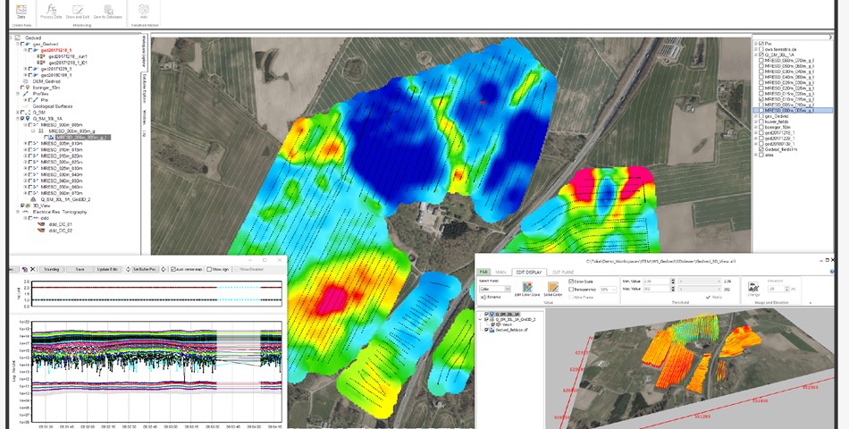
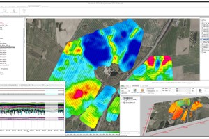
Aarhus GeoSoftware, a spinoff company from Aarhus University in Denmark, develops the software packages AGS Workbench, SPIA, Res2DInv, and Res3DInv for the processing, inversion, and visualization of geophysical data from ground-based and airborne electromagnetic (EM), electrical resistivity tomography (ERT) remote sensing, and other sources. AGS software enables users to create 2D and 3D images of subsurface electrical resistivity.
The outputs of the software can be used to distinguish and differentiate subsurface materials and can subsequently be modeled in Seequent’s Leapfrog to aid in various subsurface investigations.
The software uses electric field measurements, collected at ground level or with airborne sensors, to map the subsurface distribution of certain materials such as water, mineral deposits, and clays. Electrical resistivity allows a better understanding of the distribution of materials such as water, mineral deposits, and clays, and when the water contains other compounds such as salt, researchers and industry professionals can infer the distribution.
The genesis of AGS software was to ensure clean drinking water for future generations by mapping groundwater across Denmark. It is now used in many different areas, including locating subsurface faults and cavities to mitigate construction risk, in mining for investigating orebodies and waste rock and tailing processes, monitoring movements of groundwater and contaminants to help understand environmental impacts, modeling dam and tunnel stability, and assessing landslide risk to gauge asset resilience or construction plan impacts.
Seequent will continue its tradition of collaborating with universities and research organizations worldwide through ongoing engagement with Aarhus University for the development of AGS geophysical solutions.
GEO SPATIAL
www.geodrillinginternational.com/